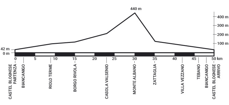
The route of 50 Km of Romagna, tend to climb in the first half and in the second downhill, runs on paved roads immersed in the green hills of the valley of the Senio.
It starts from Piazza Bernardi in Castel Bolognese and head towards Biancanigo, small fraction at more than 2 km, from where you go back to Piazza Bernardi; after a second pass on the start line head back to Biancanigo, then take the “Casolana” road.
Following the Senio valley we arrive at Cuffiano and at 10th km you enter in Riolo Terme, where it runs to the side of the Sforza Castle of the fourteenth century; after a slight descent path has a flat stretch of about 3 km, to the village of Isola, where begins the ups and downs that lead to Borgo Rivola.
From Borgo Rivola path takes it all in steady climb up to Casola Valsenio, the halfway point of the race, and from here, after a short and steep descent, starts the climb to Monte Albano, 5 km with a vertical drop of 265 m. Once you reach the top of Monte Albano he dives into a descent of 4.5 km that leads to Zattaglia. It then follows the river Sintria, you face a couple of climbs, until you get to Villa Vezzano, 9 km to the finish line.
From now on the route is all downhill; a couple of kilometers from the finish line you cross again the village of Biancanigo and you walk back the first few kilometers of the race to reach the finish line in Piazza Bernardi.